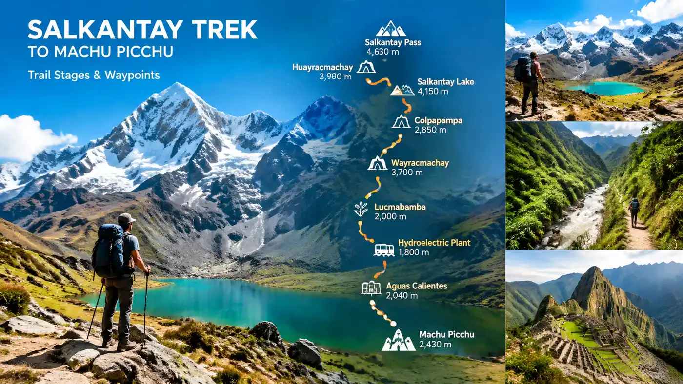
Salkantay Trek Route Map, Trail Stages, and Waypoints
I still remember sitting on a low bench in a Cusco café, spreading out a wrinkled topographic sheet and trying to trace the contour lines. The lines were crowded so tightly together near the pass that the paper looked almost black. Looking at a salkantay trek map for the first time is intimidating. You start in dry, dusty scrub country, climb straight into biting sub-zero glacial scree, drop down into dripping cloud forest where avocados fall on the path, and end up staring at the stone terraces of Machu Picchu. It covers around 74 kilometers in total, though your boots will probably log closer to 80 once you factor in wandering around campsites.
Most guidebooks simplify the route into a tidy, straight line with five neat dots. Real trails never work like that. Rivers wash out bridges, mudslides push detours along dirt vehicle tracks, and some trail forks lead straight into an elderly farmer's pigpen. Understanding the waypoints and elevation swings before you pack your bag keeps you from blowing out your knees on day two or hiking in total darkness along an abandoned train track.
Book your salkantay trek to machu picchu experience:
Reading the Salkantay Trekking Map: Trailhead to the High Pass
The journey actually starts in Mollepata, a sleepy agricultural town about two hours west of Cusco. Most hikers skip walking the dusty dirt road out of town. You will likely take a private van or shared colectivo up past the switchbacks to Challacancha, sitting right at 3,600 meters. This is the true hiking trailhead. From here, you walk alongside an ancient concrete water canal. The water rushes quietly beside you while the valley drops away hundreds of meters to your right. It is flat, easy walking for about nine kilometers, which lulls you into thinking this whole trek might be a breeze.
Soraypampa changes your mind immediately. It is a wide, windswept plateau framed by two massive peaks: Humantay to the west and Salkantay looming dead ahead. The wind here cuts through fleece like paper. Most groups drop their heavy gear in domes or tents here around midday, take a short breather, and then hike the brutal, steep two-hour trail up to Humantay Lake at 4,200 meters. The lake is an absurd shade of turquoise, fed directly by the hanging glacier above. Walking up there is not just for the photos, though. It forces your lungs to adjust to thin air before you tackle the pass the next morning. If you want a detailed look at the numbers, check our breakdown of the altitude and elevation profile across these early stages.
Note: Wind speeds at Soraypampa regularly pick up hard around 4:00 PM. Stake your tent down immediately upon arrival, because chasing a loose rainfly across a freezing boulder field at dusk is miserable.
Leaving Soraypampa before dawn on day two is freezing. Your water bottles might freeze solid in your side pockets during the first hour. The trail climbs steadily past a waypoint called Salkantaypampa, then hits a grueling set of switchbacks locally known as the "Seven Snakes." It feels endless. You take ten steps, lean on your trekking poles, breathe three times, and take ten more. The summit of the pass sits at 4,630 meters, marked by a massive pile of stones called an apacheta, draped in colorful prayer flags and discarded coca leaves.
Salkantay Trek to Machu Picchu Map: The Descent into the Jungle
Standing on the pass, you are flanked by ice walls and turquoise moraine ponds. But look east, and the landscape plunges violently into a green, misty abyss. The shift happens faster than you expect. Within two hours of descending from the freezing col, the rocky slate gives way to mossy boulders and dwarf shrubs at Huayracmachay, a common lunch stop around 3,900 meters. Your knees take an absolute beating here. You lose nearly a thousand vertical meters in just under six kilometers of descent.
By the time you reach Chaullay and the neighboring hamlet of Collpapampa at 2,900 meters, the landscape has completely flipped. The air is humid, heavy with oxygen, and smelling of damp dirt. You will find tiny wooden kiosks selling cold Cusqueña beer and fresh passion fruit. The switch from sub-polar mountain pass to the eyebrow of the Amazon jungle takes less than five hours of walking. The river running alongside the trail here is the Santa Teresa, an angry, churning torrent of glacial runoff that carves the canyon you will follow for the next day.
Pro tip: Pack insect repellent in your waist belt pocket on pass day. The sandflies at Chaullay are tiny, silent, and bite through thin leggings before you even realize you have left the high alpine zone.
From Collpapampa, the trail meanders through bamboo thickets and small coffee plots. Local families have built rustic hanging bridges across the river tributaries. You pass thundering waterfalls tumbling straight down into the trail. The path rolls up and down, never climbing steeply, but constantly working your calves. Most hikers end this stage around Lucmabamba or Sahayaco, two rural settlements surrounded by avocado groves and shade-grown coffee plants.
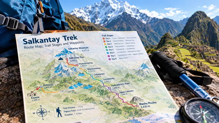
Stage-by-Stage Breakdown of the Salkantay Trek Itinerary
Planning daily distances is tricky because trekking companies split the stages differently. Some push hard through the high country to give you more time near the ruins, while others spread the mileage evenly. If you are comparing standard routes, our 5-day itinerary guide walks through the exact hour-by-hour camp schedules.
Here is how the trail breaks down geographically across the classic route, waypoint by waypoint:
| Stage & Trail Segment | Start Elevation | End Elevation | Distance | Typical Hiking Time |
|---|---|---|---|---|
| Challacancha to Soraypampa (plus Lake) | 3,600 m | 3,900 m (Lake 4,200 m) | 13 km | 5 to 6 hours |
| Soraypampa to Chaullay (via Pass) | 3,900 m | 2,900 m (Pass 4,630 m) | 22 km | 8 to 9 hours |
| Chaullay to Lucmabamba | 2,900 m | 2,050 m | 15 km | 5 to 6 hours |
| Lucmabamba to Aguas Calientes | 2,050 m | 2,040 m (Pass 2,810 m) | 18 km | 6 to 7 hours |
| Aguas Calientes to Machu Picchu | 2,040 m | 2,430 m | 4 km | 1.5 hours (or bus) |
Looking at the numbers on a salkantay trekking map, day two clearly demands the most respect. That 22-kilometer push over a frozen pass and down through ankle-rolling scree breaks a lot of hikers. If your boots are not broken in, that single day will lift the skin right off your heels.
Book your salkantay trek to machu picchu experience:
Navigating the Map of Salkantay Trek to Machu Picchu via Llactapata
When you reach Lucmabamba, you face a major navigational choice that does not always appear clearly on basic trail maps. Cheap tours often load hikers into minivans and drive them around the mountain along a dusty road to Hidroeléctrica to save money. Skip that if you can. The authentic path climbs straight up through cloud forest along an original cobblestone Inca road heading for Llactapata pass.
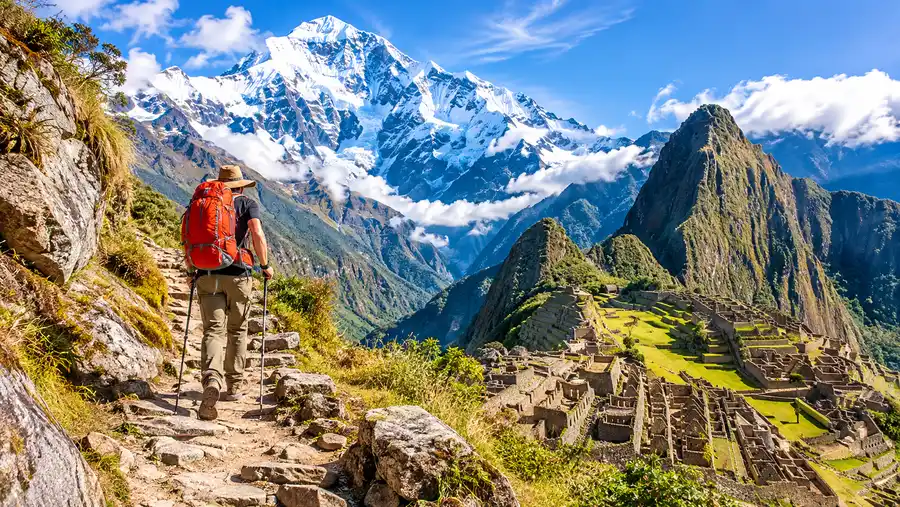
The climb up to Llactapata is sweaty, humid, and steep. You gain roughly 750 meters of elevation under dense canopy where hummingbirds dart between orchids. But the crest of the hill hides an incredible prize: the unrestored ruins of Llactapata. Stand among the crumbling stone walls, look directly across the Aobamba valley, and there it is. Machu Picchu sits perched on its green ridge three kilometers away as the crow flies. Seeing the citadel from this angle, totally isolated and framed by mountains, beats the view from the tourist gate every single time.
A few waypoints along this section require your attention so you do not wander off the path:
- Lucmabamba coffee turnoff: Look for the stone archway just past the suspension bridge; do not follow the wide dirt vehicle road continuing downstream.
- Llactapata viewpoint clearing: The trail forks slightly near the pass summit, with the left spur leading to a small family campsite and the right descending directly through the ruins.
- Aobamba River crossing: A steep, knee-crunching descent drops you to a modern footbridge over the river before reaching the Hidroeléctrica train platform.
- The railway junction: Once you reach the train tracks, turn left and simply walk alongside the rails for ten flat kilometers until you hit the outskirts of Aguas Calientes.
Walking the tracks from Hidroeléctrica to Aguas Calientes feels surreal. You walk on chunky gravel ballast between the ties while lush jungle walls rise a thousand meters on either side of the Urubamba River gorge. Occasionally a blue PeruRail train creeps past, blowing its horn so you step off into the brush. It is flat, mindless walking, which is honestly a relief after three days of relentless climbing and dropping.
Practical Offline Mapping and Route Finding Tips
Mobile reception on this trail is spotty at best. You will catch a weak signal around Mollepata, lose it completely thirty minutes past Challacancha, and get nothing until you crest the ridge at Llactapata. Do not expect to pull up an interactive map on the fly without preparing your phone ahead of time.
Paper maps still hold immense value out here, mostly because lithium phone batteries hate cold mountain air. A freezing night at Soraypampa will suck forty percent of your phone charge while you sleep, even if the device stays turned off. Keep your electronics wrapped in a wool sock inside your sleeping bag.
- Offline navigation apps: Download the entire Cusco and Vilcabamba region in Organic Maps or Maps.me before leaving your hotel. Both show the footpath, fresh water springs, and even tiny trailside snack huts with surprising accuracy.
- Topographic lines: If using apps like Gaia GPS, download the OpenCycle or outdoor topo layer so you can actually read the elevation contours rather than guessing how steep that next ridge is.
- Physical trail signage: The Peruvian Ministry of Culture has placed rustic wooden trail posts every couple of kilometers, though half the distance numbers have weathered away or been scratched off.
- Power bank essentials: Bring at least a 10,000 mAh battery pack. With no electricity between Soraypampa and the lower valley, keeping your phone alive for emergency navigation is entirely on you.
The trail itself is generally obvious, beaten into the dirt by thousands of hikers and pack mules over the decades. Getting lost in the high alpine section is difficult unless thick fog rolls in over the pass. In a whiteout, those tall piles of stones marking the route become your lifeline. Follow them carefully, and never drift down into uncharted drainage gullies looking for shortcuts.
Frequently Asked Questions about salkantay trek map
Is the Salkantay Trek route easy to follow without a guide?
Yes, the main trail is well-trodden and fairly obvious during the dry season. The main navigation challenges happen at river crossings and road junctions between Chaullay and Lucmabamba. Having a reliable offline GPS app on your phone makes independent hiking straightforward.
Where does the Salkantay Trek map officially begin and end?
The classic hiking route begins at Challacancha, just outside Mollepata, and ends at the entrance gate of Machu Picchu above Aguas Calientes. Some variations start further back in Mollepata or cut the hike short at Hidroeléctrica by taking the train.
Can I avoid walking the train tracks from Hidroeléctrica?
You can buy a ticket for the local tourist train at the Hidroeléctrica station to skip the flat ten-kilometer walk along the tracks. Tickets cost roughly $35 to $45 for foreigners and take about forty minutes to reach Aguas Calientes.
Quick Reference
- Total distance: roughly 74 kilometers (46 miles)
- Highest waypoint: Salkantay Pass at 4,630 meters (15,190 ft)
- Lowest trail point: Aguas Calientes valley floor at 2,040 meters (6,692 ft)
- Hardest section: 800m vertical climb up the Seven Snakes switchbacks
Book your salkantay trek to machu picchu experience:
My Take on Reading the Trail
A map tells you about distance and elevation, but it can never prepare you for how the air tastes at four in the morning under Salkantay's frozen face. The numbers look intimidating on a screen, yet once you put your head down and find an easy walking rhythm, the trail unfolds one switchback at a time. Study the stages, respect the altitude jumps, keep your maps cached offline, and go experience one of the wildest corners of the Andes for yourself.
Read more about salkantay trek to machu picchu.